Chapter 8 — Deformation Monitoring: Survey and Geotechnical Sensors
8.1 Movement is the ultimate signal
Deformation — movement of the dam or foundation — is often the most direct sign of distress. It is monitored both at the surface (survey) and internally (geotechnical sensors).
8.2 Surface deformation — survey
A survey control network of monuments on the dam crest, slopes, and abutments is the backbone of deformation monitoring:
- Total station / GNSS measures horizontal and vertical position to millimeters.
- Frequency ranges from monthly in steady state to daily during construction or after an event.
- Datums must be on stable ground outside the zone of influence.
Survey reveals settlement, crest shortening, and slope bulging.
8.3 Internal deformation — inclinometers
An inclinometer measures lateral displacement of a casing installed in a borehole. It detects shear surfaces (the depth where movement concentrates) — the signature of slope instability or internal erosion.
- Install casing through the zone of concern, anchored below it.
- Read from the bottom up; the bottom is the reference.
- Casing integrity is critical: a cracked or offset casing gives false readings.
8.4 Internal deformation — extensometers and settlement systems
- Extensometers (rod, magnetic, wireline) measure movement between an anchor deep in stable ground and a point nearer the surface — detecting settlement or heave at specific depths.
- Settlement systems (liquid, magnetic, settlement gauges) track vertical movement across an embankment.
8.5 Tiltmeters and crackmeters
- Tiltmeters sense rotation of a surface; useful on concrete structures and steep slopes.
- Crackmeters / joint meters measure opening of cracks or joints in concrete dams, abutments, and foundations.
8.6 Combining measurements
Deformation is most powerful when correlated: a surface survey shows where the dam moved; an inclinometer shows at what depth; piezometers show why (pore-pressure change). Together they localize the mechanism.
Build a deformation baseline early
Embankments settle as they consolidate; the first years define the normal settlement rate. Later acceleration stands out clearly against that baseline.
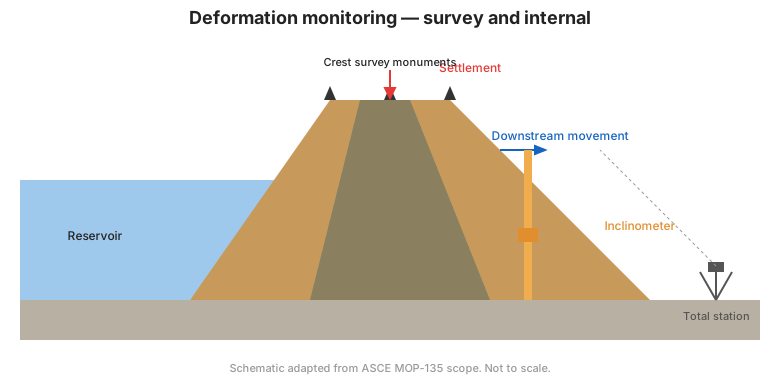
Figure. Deformation monitoring: crest survey monuments (settlement, downstream movement) plus an inclinometer for internal shear (ASCE MOP-135 scope).
8.7 Key takeaways
- Deformation is the most direct distress signal; monitor it inside and out.
- Survey networks give surface movement; inclinometers reveal shear depth.
- Extensometers and settlement systems give depth-resolved vertical movement.
- Correlate deformation with piezometers to identify mechanism and location.