Chapter 3 — Overview of Hardware for Deformation
3.1 Introduction
Deformation is the parameter that most directly reveals whether the ground or a structure is behaving as predicted. Instruments for measuring deformation span a wide range, from simple surface crack gages to deep borehole inclinometers. They are grouped into categories (surface vs. subsurface; discrete vs. profile) so that the right instrument can be matched to the geometry of the expected movement.
3.2 Surveying methods
Optical and GPS surveying measure the movement of surface points — settlement, heave, and horizontal displacement — relative to stable reference monuments. They give a broad, low-cost overview and are often the first line of deformation monitoring, but they cannot see movement at depth.
3.3 Crack gages
Crack gages monitor the opening or closing of a single crack or joint:
- Mechanical types: pins-and-tape, pins with a steel rule or calipers, pins with tensioned wire and weight, the grid crack monitor, mechanical strain gage, and dial indicator.
- Electrical types: transducers that convert crack movement to an electrical signal for logging.
3.4 Convergence gages
Convergence gages measure the change in distance between two points on a structure — for example, the narrowing of a tunnel or the closure of an excavation.
3.5 Tiltmeters
A tiltmeter measures rotation of a surface or structure from the change in orientation of a sensor. Two common transducer types are:
- Accelerometer-based tiltmeters — robust, used for structural and ground tilt.
- Electrolytic-level tiltmeters — very high resolution for small rotations.
3.6 Probe extensometers
A probe extensometer measures displacement at discrete depths along a borehole by lowering a probe to magnetic or inductive targets:
- Induction-coil gages — a probe detects the position of metal targets.
- Magnet / reed-switch gages — a probe detects ring magnets grouted at chosen depths.
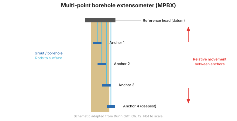
Figure. Probe and fixed extensometer principles: targets/anchor points at depth record movement relative to a stable reference (after FHWA-HI-98-034, Ch. 3).
3.7 Settlement platforms and subsurface settlement points
- Settlement platforms — surface plates (often with risers) that record fill settlement as embankments are built.
- Subsurface settlement points — anchors placed at depth, either a driven or grouted anchor or a Borros anchor, to record settlement of a buried layer.
3.8 Fixed borehole extensometers and series extensometers
- Fixed borehole extensometers — permanently installed anchors with rods or wires to a reference head, giving continuous measurement of the distance between fixed depths.
- Series extensometers — a stack of anchors in one borehole that resolves deformation into increments between adjacent anchors, useful for locating the zone of movement.
3.9 Inclinometers
The inclinometer is the workhorse for measuring horizontal deformation with depth — in slopes, embankments, excavations, and around foundations. A probe with two orthogonal servo-accelerometers travels along a grooved casing, and the accumulated tilt gives the deflection profile.
Variants include:
- Horizontal inclinometers — measure settlement profiles along a horizontal casing.
- In-place (fixed) inclinometers — a string of sensors left in the casing for continuous, automated monitoring.
- Shear-plane indicators — detect the depth at which a casing shears.
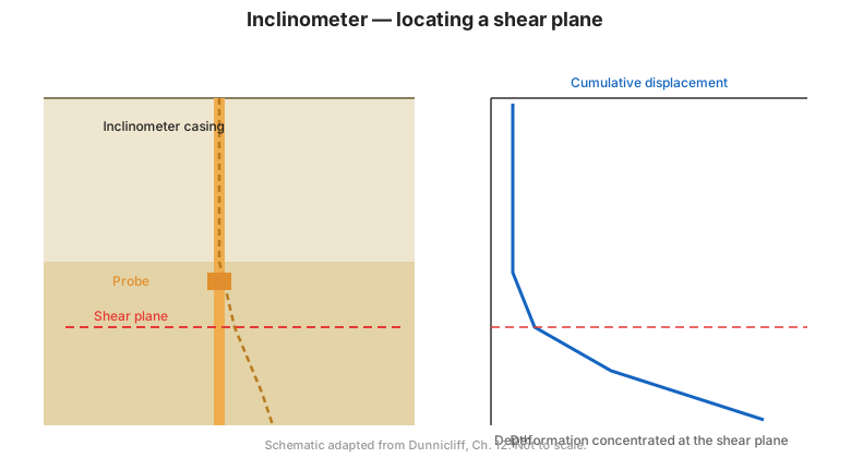
Figure. Inclinometer principle: the probe traverses grooved casing and the cumulative tilt yields the deflection profile with depth (after FHWA-HI-98-034, Ch. 3).
3.10 Liquid-level gages
Liquid-level (settlement) gages use a liquid-filled tube connected to a cell to measure settlement or heave by the change in pressure or liquid level:
- Single-point gages — with both ends at the same elevation, with the readout unit higher than the cell, or with the cell and tube installed within a borehole.
- Full-profile gages — a series of cells giving a complete settlement profile.
3.11 Telltales and slurry-trench convergence gages
- Telltales — simple rods or wires anchored at depth that measure movement of a specific point relative to the surface; multiple telltales resolve movement between several points.
- Convergence gages for slurry trenches — hydraulic gages that measure the convergence of a trench during construction.
3.12 Metallic time-domain reflectometry (TDR)
Metallic TDR sends a pulse down a coaxial cable and detects reflections from kinks or breaks caused by ground movement. It is a low-cost way to detect and locate shear deformation in soil and rock.
3.13 Acoustic emission monitoring
Acoustic emission (AE) monitoring detects the high-frequency sound generated when soil or rock grains slip and break. Counting emission events or the count rate gives early warning of developing instability.
3.14 Key takeaways
- Deformation instruments range from surface survey to deep borehole profiling.
- Inclinometers are the standard for horizontal movement with depth; extensometers for vertical or axial movement.
- Series extensometers and multiple telltales resolve movement between anchors to locate the active zone.
- TDR and acoustic emission are low-cost early-warning tools.
- Match the instrument's range and resolution to the magnitude of movement you expect.