Chapter 1 — Geology: Soil and Rock
Chapter I sets the geological stage. Before any foundation can be designed, the engineer must understand what the ground is made of and how it was formed.
Illustrations in this chapter
The photographs in this chapter are taken from the openly licensed textbook Physical Geology – 2nd Edition by Steven Earle (BCcampus, CC BY 4.0), used with attribution. See the geology figure credits for the full list. Only CC BY / public-domain figures are used.
1.1 Where geotechnics sits
The handbook separates three related disciplines:
- Geology (địa chất học) — the science of the Earth: its composition, structure, formation, movement, tectonic evolution and change.
- Engineering geology (địa chất công trình, ĐCCT) — the branch of geology that studies the geological environment for construction: it characterises the ground, selects the site, and supplies the geological inputs to foundation design.
- Geotechnique (địa kỹ thuật) — the applied discipline that binds ĐCCT together with soil mechanics and foundation engineering (cơ đất & nền móng). Its job is to turn geological description into numbers a designer can use.
The handbook's practical point: ĐCCT on its own stays too qualitative, while soil mechanics on its own assumes too much about uniform ground. Geotechnique is where the two meet — and its conclusions decide the foundation type, the foundation dimensions, the ground treatment and the construction method.
1.2 Structure of the Earth
The Earth is layered — concentric shells of distinctly different physical properties, separated by discontinuity surfaces or zones (bề mặt hoặc vùng không liên tục). Geophysics detects these boundaries because the velocity of seismic waves changes abruptly across them; a local departure from the expected velocity is an anomaly (dị thường).
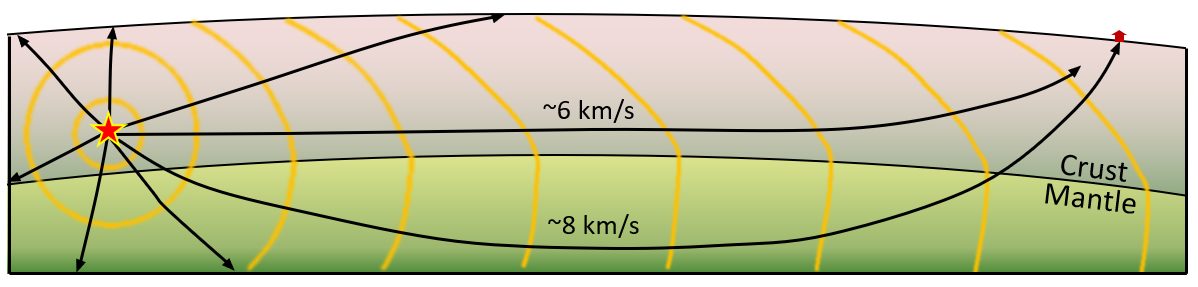
Figure. How a seismic boundary is detected. Waves that travel down into the mantle are bent upward and reach the station before the waves that travelled only through the crust — the observation that revealed the crust–mantle boundary (the Moho). © Steven Earle, CC BY 4.0 — Physical Geology, 2nd ed., Fig. 9.1.5.
For the engineer the consequences are concrete: rock type, degree of weathering, depth to sound rock, and the presence of weak or fractured zones.
1.3 The three main rock families
1.3.1 Igneous rock (đá magma)
Formed by the cooling and crystallisation of molten material. Intrusive rocks (xâm nhập) such as granite cool slowly at depth and are coarse-grained; extrusive rocks (phun trào) such as basalt and andesite cool quickly at the surface and are fine-grained. In Vietnam, basalt plateaus in the Central Highlands and the Southeast weather into laterite — a soil, not a rock, by the time the engineer meets it.
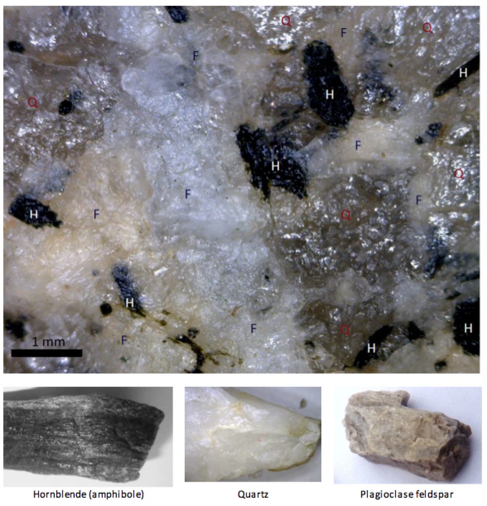
Figure. A close-up of granite and some of the minerals it contains — H = hornblende, Q = quartz, F = feldspar. Crystals range from about 0.1 to 3 mm across. The interlocking crystal fabric of an intrusive igneous rock is why it is strong when intact but can behave as a set of loose blocks once jointed. © Steven Earle, CC BY 4.0 — Physical Geology, 2nd ed., Fig. 1.4.2.
1.3.2 Sedimentary rock (đá trầm tích)
Formed by deposition, burial and consolidation. Clastic rocks (mảnh vụn) — sandstone, siltstone, shale — are classified by grain size; chemical and organic rocks include limestone and dolomite. Two features dominate their engineering behaviour: bedding planes (mặt phân lớp), which are planes of weakness, and, in limestone, karst — caves, sinkholes and solution channels that make foundations and tunnels unpredictable. Vietnam's northern limestone ranges are classic karst terrain.
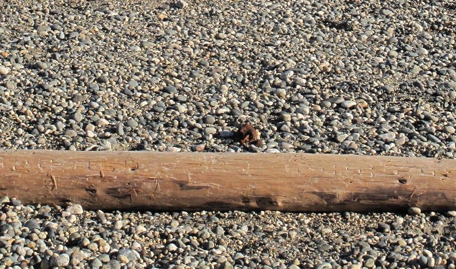
Figure. Pebbles on an ocean beach — the raw material of clastic sediment. The grain size, sorting and rounding visible here are the same properties the engineer reads off a borehole log to name and classify the deposit. © Steven Earle, CC BY 4.0 — Physical Geology, 2nd ed., Fig. 6.1.1.
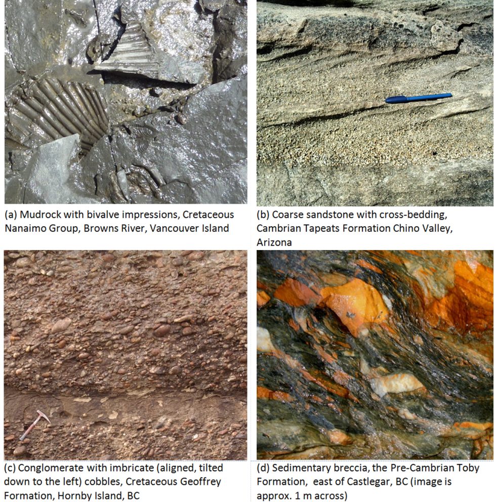
Figure. Examples of clastic sedimentary rocks. Note how widely texture and cementation vary — the single biggest control on the strength and deformability of a sedimentary foundation. © Steven Earle, CC BY 4.0 — Physical Geology, 2nd ed., Fig. 6.1.8.
1.3.3 Metamorphic rock (đá biến chất)
Formed from existing rock under heat and pressure: gneiss (gơnai), schist (đá phiến), marble (đá hoa), quartzite (quaczit), slate (đá phiến sét). Metamorphism produces foliation (cấu tạo phiến) — a strong directional fabric that makes strength and deformability strongly anisotropic: the rock is far weaker across the foliation than along it.
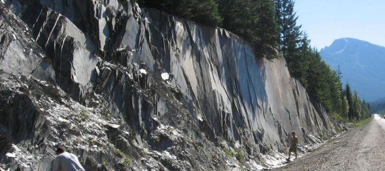
Figure. Slate at a road cut in the Columbia Mountains, B.C., peeling along its foliation planes. This directional fabric — not the rock's intact strength — governs how the cut stands and how it will fail. © Steven Earle, CC BY 4.0 — Physical Geology, 2nd ed., Fig. 5.1.2.
1.4 Weathering and the state of the ground
Weathering is the process that converts rock into soil — and the process that most often decides whether a foundation sits on sound material or on a weakened, structured mass. The handbook's point is that the state of weathering matters more than the rock name. Four mechanisms do most of the work:
- Unloading / exfoliation — removal of overburden lets the rock expand and crack parallel to the ground surface.
- Frost wedging — water in cracks freezes, expands and prises the rock apart; the most effective mechanism in a climate like Vietnam's northern highlands.
- Salt crystallisation — salts grow in pores and push grains apart, producing honeycomb surfaces.
- Root and biological action — roots widen every crack they enter.
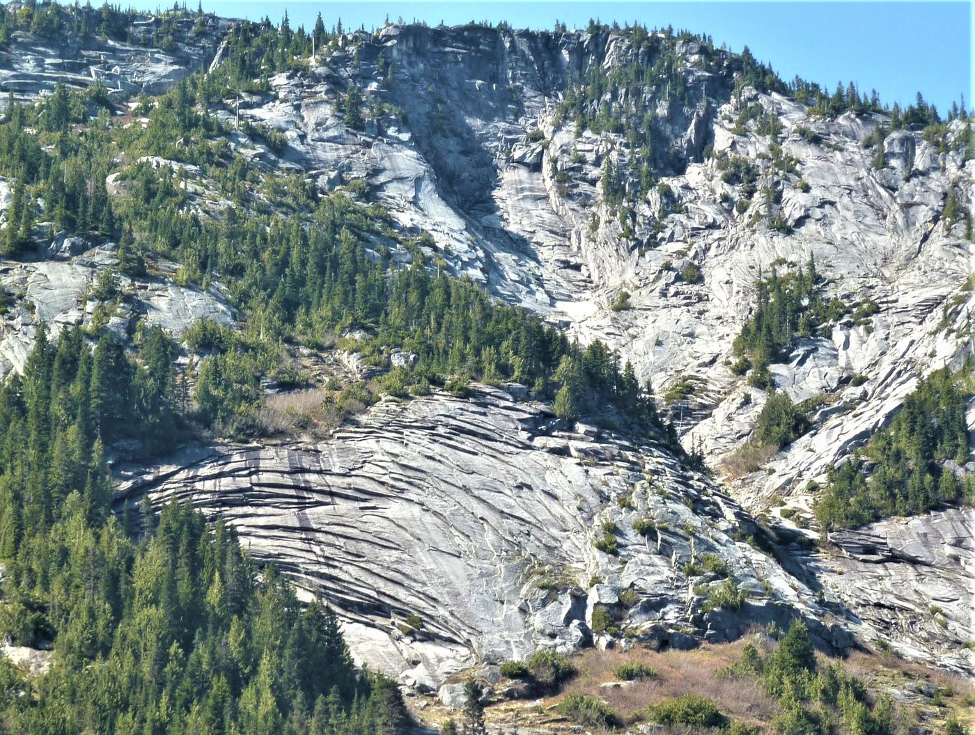
Figure. Exfoliation fractures in granitic rock exposed by a highway cut (Coquihalla Highway, B.C.). The rock is peeling off in sheets parallel to the new ground surface because the confining pressure was removed. © Steven Earle, CC BY 4.0 — Physical Geology, 2nd ed., Fig. 5.1.1.
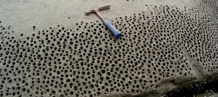
Figure. Honeycomb weathering of sandstone (Gabriola Island, B.C.). Salt crystallising in the pores has prised the grains apart, leaving a pitted surface with almost no intact strength. © Steven Earle, CC BY 4.0 — Physical Geology, 2nd ed., Fig. 5.1.5.
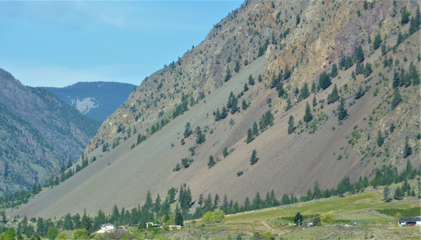
Figure. A talus deposit at the foot of a frost-shattered cliff (Keremeos, B.C.). The weathered debris that collects here is colluvium — a loose, poorly sorted, often metastable material that the engineer must recognise on site. © Steven Earle, CC BY 4.0 — Physical Geology, 2nd ed., Fig. 5.1.4.
1.5 Structure: bedding, foliation and faults
Two rock masses with the same intact strength can behave completely differently once structure is taken into account. The controlling features are bedding planes, foliation, joints and faults — and, critically, their orientation relative to the load or the cut.
Figure. A fault (white dashed line) in intrusive rock on Quadra Island, B.C. A pink dyke has been offset about 10 cm by right-lateral movement. A fault is a plane of already-broken rock: it is a discontinuity in the ground model, not a line on a plan. © Steven Earle, CC BY 4.0 — Physical Geology, 2nd ed., Fig. 12.3.4.
Figure. The McConnell Thrust at Mt. Yamnuska, Alberta. Cambrian limestone has been thrust over Cretaceous mudstone — an 800 m-thick sheet pushed some 40 km. Where a thrust carries strong rock over weak rock, the weak unit controls the design. © Steven Earle, CC BY 4.0 — Physical Geology, 2nd ed., Fig. 12.3.9.
1.6 What the engineer takes from this
Rock type alone does not determine behaviour. The controlling factors are the state of weathering, the degree of jointing/fracturing, and the orientation of bedding or foliation relative to the load. A "strong" granite cut by closely spaced joints may perform worse than a well-bedded sandstone.
1.7 Terminology
| English | Vietnamese (book) |
|---|---|
| geology | địa chất học |
| engineering geology | địa chất công trình (ĐCCT) |
| geotechnique | địa kỹ thuật |
| soil mechanics and foundations | cơ đất & nền móng |
| discontinuity | bề mặt / vùng không liên tục |
| anomaly | dị thường |
| igneous rock | đá magma |
| intrusive / extrusive | xâm nhập / phun trào |
| sedimentary rock | đá trầm tích |
| clastic | mảnh vụn |
| metamorphic rock | đá biến chất |
| bedding plane | mặt phân lớp |
| foliation | cấu tạo phiến |
| karst | các-tơ (karst) |
| weathering | phong hoá |
| exfoliation | bong tróc (unloading) |
| frost wedging | nêm băng (nứt do băng) |
| talus / colluvium | tích tụ sườn (taluy) |
| fault | đứt gãy |
| joint | khe nứt |
1.8 Key takeaways
- Geotechnique = ĐCCT + soil mechanics & foundations. Neither half is sufficient alone.
- The Earth is layered; geophysics finds the boundaries by their effect on wave velocity.
- Rock behaviour is governed by weathering, jointing and fabric orientation, not by rock type alone.
- Weathering is what turns rock into soil — exfoliation, frost wedging, salt growth and roots all break the mass before the engineer ever drills it.
- Karst limestone and foliated metamorphic rock are the two most unpredictable ground types in Vietnam.