Chapter 3 — Groundwater
Groundwater cannot be separated from geotechnical investigation. Chapter III gives the minimum groundwater theory a geotechnical engineer needs, then describes the main groundwater types.
3.1 Basic concepts
3.1.1 The porous medium
To talk about groundwater you must first talk about the porous medium (môi trường rỗng) — the soil or rock in which water moves. Every soil and rock contains voids, and they arise in two different ways:
- Interstitial voids (khe rỗng giữa hạt) — the spaces between individual grains, created when the material was deposited.
- Structural voids (khoáng rỗng kiến tạo) — voids created later by geological processes: fissures, cracks, fractures, root holes, burrows, dissolution.
This distinction matters because the two void systems behave differently and must be described differently.
3.1.2 Tortuosity
Tortuosity (độ uốn lượn) describes how crooked the actual flow path is compared with the straight-line distance — it reduces the effective flow through a medium.
3.1.3 Void ratio and related characteristics
The degree of voiding (mức độ rỗng) and the associated parameters (void ratio \(e\), porosity \(n\)) quantify how much of the medium is void.
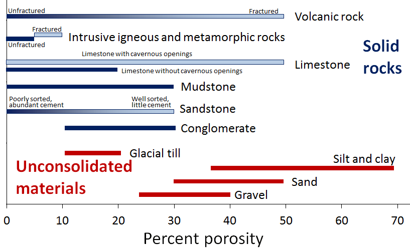
Figure. Typical porosity ranges for unconsolidated materials (red) and rocks (blue). Note that silt and clay are the most porous — yet, as the next figure shows, the least permeable. © Steven Earle, CC BY 4.0 — Physical Geology, 2nd ed., Fig. 14.1.1.
3.1.4 Degree of permeability
Permeability (mức độ thấm) is the capacity of the medium to transmit water. It is the single most important property for seepage, drainage and consolidation problems.
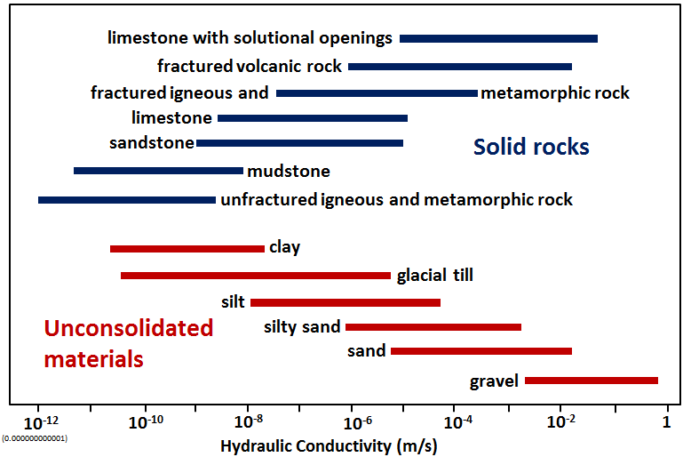
Figure. Hydraulic conductivity \(K\) (m/s) for unconsolidated materials (red) and rocks (blue) — a range of some twelve orders of magnitude. Clay is porous but nearly impermeable, because almost all of its water is held as bound water on the grain surfaces and cannot flow. © Steven Earle, CC BY 4.0 — Physical Geology, 2nd ed., Fig. 14.1.2.
3.1.5 Moisture content and degree of saturation
Moisture content (độ ẩm) and degree of saturation (độ bão hoà) describe how much of the void space is filled with water.
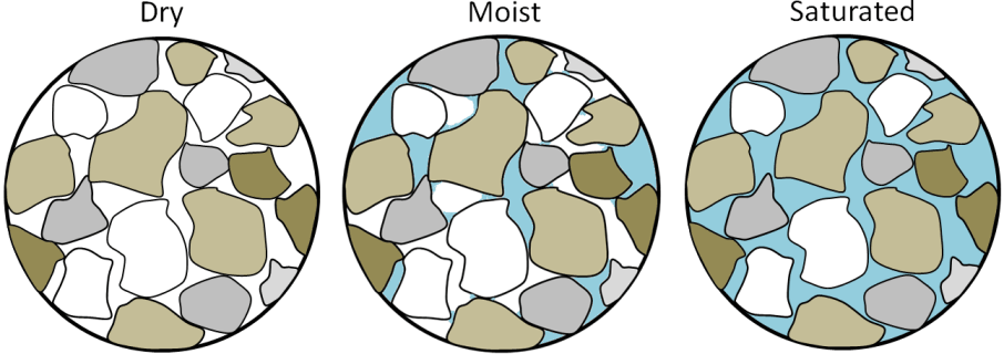
Figure. Dry, moist and saturated sand. Surface tension between grains makes moist sand the strongest of the three; saturated sand is the weakest, because water under pressure pushes the grains apart and reduces friction. This is the mechanism behind liquefaction (Chapter 11). © Steven Earle, CC BY 4.0 — Physical Geology, 2nd ed., Fig. 15.1.4.
3.1.6 Surface tension
Surface tension (sức căng bề mặt) is the force that lets water support itself in narrow voids and is the physical cause of capillarity.
3.1.7 Capillary action
Capillary rise (hiện tượng mao dẫn) lifts water above the free water table in fine soils. The capillary zone is not saturated in the usual sense, but its negative pore pressure changes effective stress and therefore strength — a recurring theme in slope and retaining-wall problems.
3.2 The main groundwater types
3.2.1 Groundwater in granular sediments
Water held in the pore system of sands, gravels and silts. It is the most predictable aquifer type and the one in which Darcy's law (Chapter 10) applies most cleanly.
3.2.2 Karst water
Water in solution channels and caves within limestone. Karst aquifers are highly non-uniform: flow is concentrated in conduits, and the same formation can be impermeable a metre away from a major channel. Karst water is a first-order hazard for foundations, tunnels and dam abutments in Vietnam's limestone regions.
3.2.3 Distribution where permeability is uniform
Where the medium is uniformly permeable, groundwater distribution can be described analytically — the basis for the flow-net and seepage calculations in Chapter 10.
3.2.4 Aquifers, aquitards and confining layers
A body of ground that transmits water usefully is an aquifer (tầng chứa nước); one that does not is an aquitard or confining layer (tầng cách nước). An aquifer open to the surface is unconfined (không áp); one capped by a lower-permeability layer is confined (có áp) — and the pore pressure in a confined aquifer is what makes piezometers read above the level of the aquifer itself.
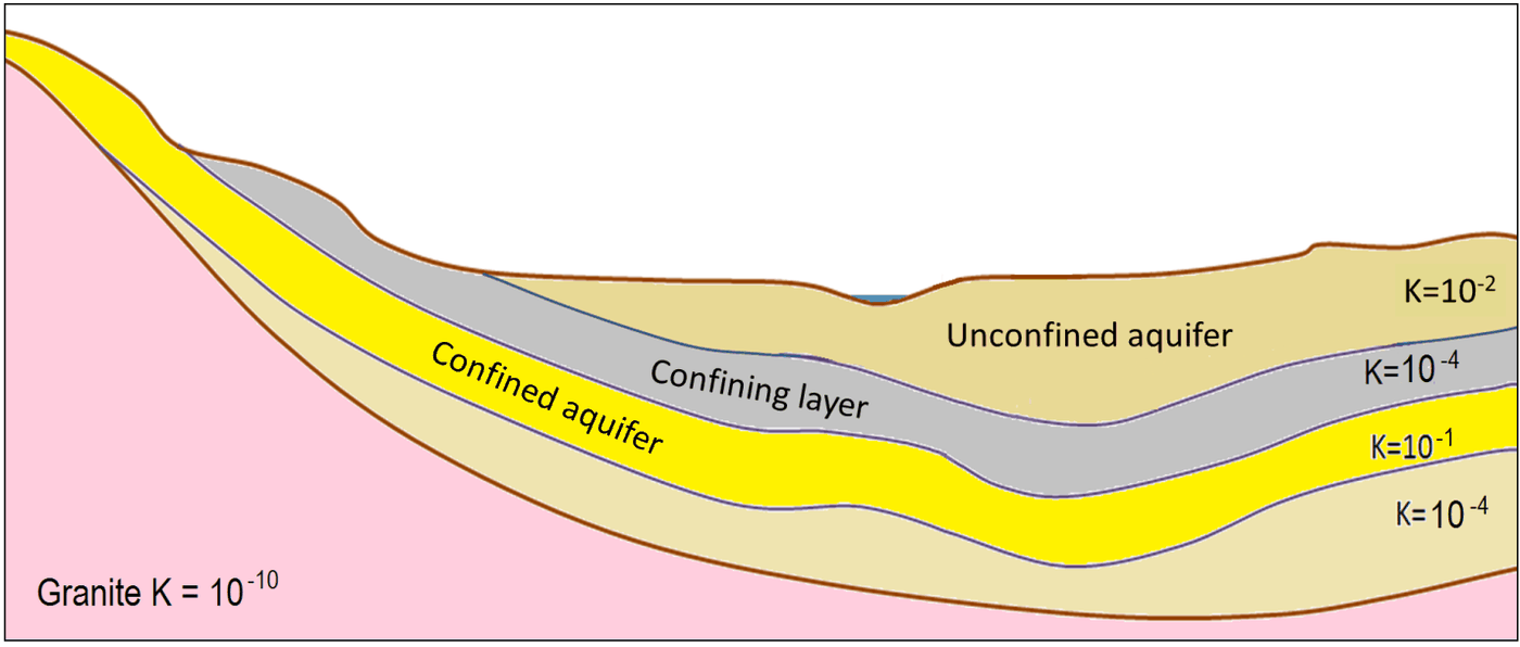
Figure. A cross-section of aquifers and confining layers, with relative permeabilities given as hydraulic conductivity \(K\) (m/s). The grey layer (\(K = 10^{-4}\)) confines the yellow aquifer (\(K = 10^{-1}\)) beneath it; the granite at the base (\(K = 10^{-10}\)) is the regional aquitard. © Steven Earle, CC BY 4.0 — Physical Geology, 2nd ed., Fig. 14.1.4.
3.3 Terminology
| English | Vietnamese (book) |
|---|---|
| porous medium | môi trường rỗng |
| interstitial void | khe rỗng giữa hạt |
| structural void | khoáng rỗng kiến tạo |
| tortuosity | độ uốn lượn |
| void ratio / porosity | hệ số rỗng / độ rỗng |
| permeability | mức độ thấm (tính thấm) |
| moisture content | độ ẩm |
| degree of saturation | độ bão hoà |
| surface tension | sức căng bề mặt |
| capillary action | hiện tượng mao dẫn |
| groundwater | nước dưới đất |
| karst water | nước các-tơ |
3.4 Key takeaways
- Interstitial and structural voids are different systems and must be described separately.
- Permeability is the property that governs seepage, drainage and consolidation.
- The capillary zone changes effective stress even though it is not saturated.
- Karst water is highly non-uniform and is a major hazard in limestone terrain.