Chapter 11 — Earthquakes and Construction Works
Chapter XI introduces earthquakes for the civil engineer: what they are, how they are described, how they are mapped in Vietnam, and how they enter the design of bridges and buildings — with the soil-mechanics problems, above all liquefaction, treated explicitly.
11.1 An overview of earthquakes
11.1.1 Definition and concepts
An earthquake is the result of deformation in the Earth's crust. Strain energy accumulates until, at some point, the resistance is weakest and the stress exceeds equilibrium: rupture then propagates rapidly, radiating seismic waves.
Key terms:
- Focus (chấn tiêu) — the point within the Earth where rupture begins.
- Epicenter (chấn tâm) — the point on the surface vertically above the focus.
- Fault (đứt gãy), active fault (đứt gãy hoạt động) — the fracture along which displacement occurs.
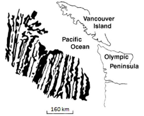
Figure. A fault (white dashed line) in intrusive rock on Quadra Island, B.C. A dyke has been offset about 10 cm — right-lateral movement. The fault itself is the plane of already-broken rock along which the rupture propagates. © Steven Earle, CC BY 4.0 — Physical Geology, 2nd ed., Fig. 12.3.4.
11.1.2 Global distribution of earthquakes
11.1.3 Causes of earthquakes
11.2 Some characteristics of earthquakes
11.2.1 Energy of an earthquake
11.2.2 Magnitude \(M\)
11.2.3 Intensity \(I\)
11.2.4 Characteristics of seismic vibration
Two body waves carry the energy away from the focus: the P wave (compression — "push–pull", the first to arrive) and the S wave (shear, slower). It is the S wave that does most structural damage, and — critically for the geotechnical engineer — S waves do not travel through liquid. Surface waves follow and are the slowest.
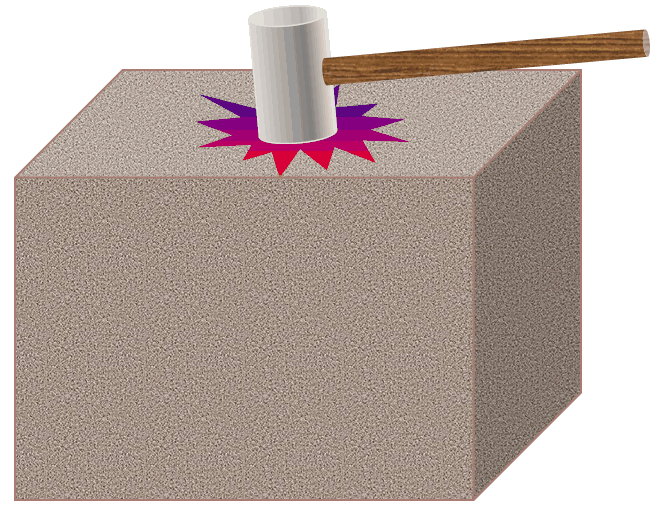
Figure. The principle behind every seismic method in geotechnical investigation: a hammer blow (or a borehole source) sends elastic waves into the ground, and the arrival times of the P and S waves at a receiver give the wave velocities of the material. © Steven Earle, CC BY 4.0 — Physical Geology, 2nd ed., Fig. 9.1.1.
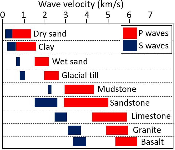
Figure. Typical P-wave (red) and S-wave (blue) velocities in sediments and in solid crustal rock. Velocities in soft sediments are an order of magnitude lower than in rock — which is why the same earthquake shakes a soft-soil site far more violently than a rock site. © Steven Earle, CC BY 4.0, after the US Environmental Protection Agency (public domain) — Physical Geology, 2nd ed., Fig. 9.1.3.
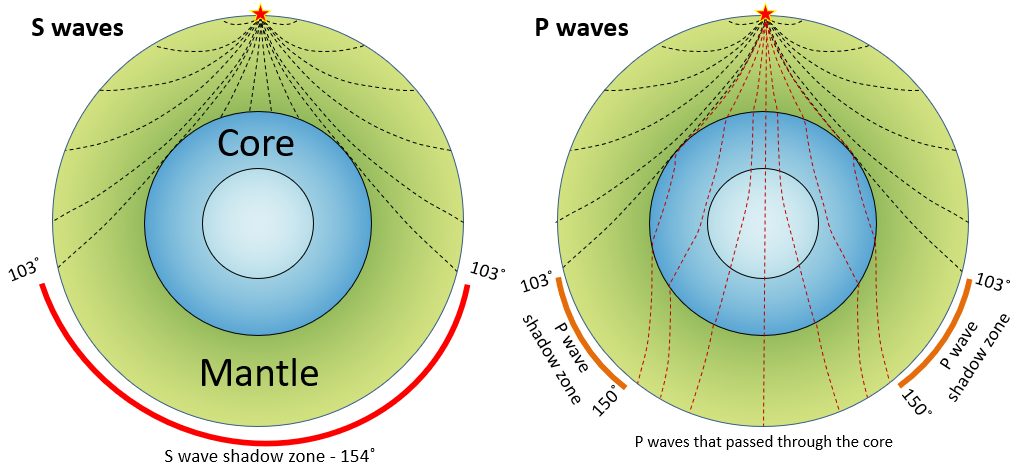
Figure. Propagation of seismic waves through the mantle and core. S waves are stopped at the core–mantle boundary, leaving an S-wave shadow on the far side of the Earth — the same physics that lets geophysics map a soft or liquid layer beneath a site. © Steven Earle, CC BY 4.0 — Physical Geology, 2nd ed., Fig. 9.1.6.
11.2.5 Attenuation law of seismic shaking
11.2.6 Consequences of earthquakes
Beyond direct shaking damage, an earthquake destabilises slopes and can trigger widespread landsliding — particularly where the ground has already been saturated by rain. The 2018 Sapporo failures are the textbook sequence: a typhoon saturated the volcanic soils, then an M6.6 earthquake triggered thousands of debris flows.
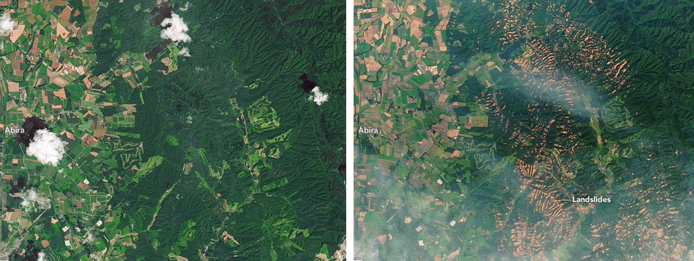
Figure. Slope failures in the Sapporo area, Japan, after a typhoon (4 Sept 2018) and an earthquake (6 Sept 2018). Before (July 2017, left) and after (September 2018, right) Landsat 8 images. Saturation followed by shaking is the classic compound trigger. "Landslides in Hokkaido" by Lauren Dauphin, NASA Earth Observatory (public domain) — Physical Geology, 2nd ed., Fig. 15.1.7.
11.3 Seismic zoning and earthquake maps
11.3.1 General
11.3.2 Earthquakes in Vietnam
Vietnam is not aseismic: the northwest (along the Red River and Lai Chau–Dien Bien fault zones) and parts of the central highlands have recorded damaging earthquakes.
11.3.3 Seismic investigation for seismic design
11.4 An overview of earthquake-resistant design
11.4.1 Design parameters
11.4.2 Soil-mechanics issues in seismic design
11.4.3 Soil liquefaction (hiện tượng hóa lỏng)
Under cyclic seismic loading, loose saturated sands can lose their strength and behave as a liquid. Liquefaction is a first-order geotechnical hazard: it destroys bearing capacity, causes lateral spreading and settlement, and has toppled structures that were otherwise well built. The handbook presents the conditions, the assessment and the mitigation.
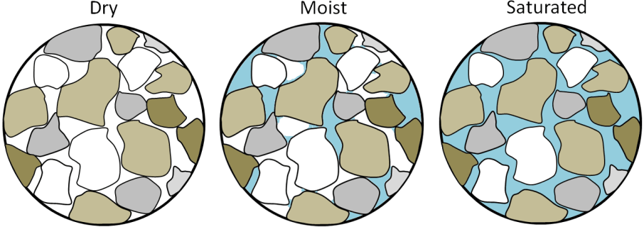
Figure. Why saturation is the precondition for liquefaction: saturated sand is the weakest of the three states, because water under pressure pushes the grains apart. Cyclic shaking removes the grain-to-grain contact altogether, and the soil behaves as a liquid. © Steven Earle, CC BY 4.0 — Physical Geology, 2nd ed., Fig. 15.1.4.
11.4.4 Earthquake effects in bridge design
11.4.5 Earthquake effects in building design
11.5 Terminology
| English | Vietnamese (book) |
|---|---|
| earthquake | động đất |
| focus | chấn tiêu |
| epicenter | chấn tâm |
| fault / active fault | đứt gãy / đứt gãy hoạt động |
| magnitude | độ lớn (chấn cấp) \(M\) |
| intensity | cường độ \(I\) |
| seismic zoning | phân vùng địa chấn |
| attenuation | tắt dần |
| seismic design | thiết kế kháng chấn (chống động đất) |
| liquefaction | hoá lỏng đất nền |
| lateral spreading | trôi ngang |
11.6 Key takeaways
- Strain accumulates in the crust and is released as rupture and seismic waves.
- Magnitude is a single number for the event; intensity varies with location.
- Vietnam does have seismicity — the northwest and central highlands in particular.
- Liquefaction of loose saturated sand is the signature geotechnical hazard and must be assessed wherever it can occur.
- Seismic design needs both the ground motion and the soil response.