Chapter 7 — Instrumentation for Soil Slopes & Embankments
7.1 Introduction
For each type of construction, the FHWA manual presents two things: the general role of geotechnical instrumentation, and the principal geotechnical questions that may arise together with the instruments that can help answer them. This chapter covers soil slopes and embankments.
7.2 Embankments on soft ground
General role. Instrumentation monitors consolidation, stability, and the effectiveness of staged construction. Pore-pressure response controls the safe rate of fill placement; settlement and horizontal movement show whether the foundation is behaving as predicted.
Principal geotechnical questions:
- Is the embankment stable, or is a bearing-capacity / slope failure developing?
- How fast is the soft foundation consolidating, and is staged construction proceeding safely?
- How much settlement has occurred, and where?
Suitable instruments (Table 7-1) typically include: piezometers (pore pressure), settlement platforms and subsurface settlement points (settlement), inclinometers (lateral movement), and liquid-level gages (settlement profile).
7.3 Cut slopes in soil
General role. Instrumentation detects the onset of instability and measures the rate of movement, so that construction or traffic can be adjusted.
Principal geotechnical questions:
- Is the cut slope stable, and what is the rate of movement?
- Where is the active shear zone?
- Is pore pressure rising toward a critical condition?
Suitable instruments (Table 7-2) typically include: inclinometers (shear zone and movement), piezometers (pore pressure), crack gages (tension cracks), and survey monuments.
7.4 Landslides in soil
General role. Instrumentation characterizes an existing or reactivated landslide — its geometry, rate, and controlling pore pressures — to guide stabilization and monitor its effectiveness.
Principal geotechnical questions:
- How deep and how fast is the landslide moving?
- What pore pressures drive it, and how do they respond to rainfall?
- Is the stabilization working?
Suitable instruments (Table 7-3) typically include: inclinometers and TDR (shear zone and rate), piezometers (pore pressure), surface survey and extensometers (movement), and rain gauges (triggering).
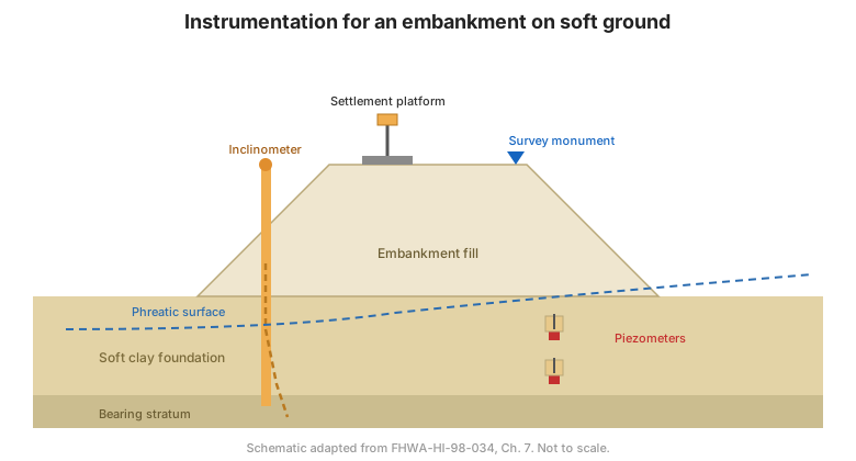
Figure. Typical instrumentation for a soil slope / embankment: inclinometer and piezometer in the slope, settlement platforms on the embankment, and survey monuments (after FHWA-HI-98-034, Ch. 7).
7.5 Student exercise — planning a soil-slope program
The manual includes a worked student exercise for planning a monitoring program for a soil slope. It steps through the planning process:
- Step 1 — definition of project conditions.
- Step 3 — predict mechanisms that control behavior.
- Step 4 — define the geotechnical questions that need to be answered.
- Step 6 — select the parameters to be monitored.
- Step 7 — predict magnitudes of change.
- Step 10 — select instruments.
- Step 12 — plan recording of factors that may influence measured data.
Worked example results are provided in Appendix C (see Chapter 14).
7.6 Key takeaways
- For embankments on soft ground, pore pressure controls the safe rate of filling — instrument it first.
- For cut slopes and landslides, the inclinometer locates the shear zone and measures rate; piezometers explain the driving pressures.
- Combine surface survey with subsurface instruments for a complete picture.
- The student exercise is the planning process (Chapter 6) applied end-to-end — practice it.